Services Offered

Construction Layout
Subdivision Layout & Design
Construction Layout
We can help get your project off the ground by laying out your project on the ground.

Boundary Surveys
Subdivision Layout & Design
Construction Layout
We will be happy to tell you where your boundary and property line is

Subdivision Layout & Design
Subdivision Layout & Design
Subdivision Layout & Design
We will do the planning, surveying, and layout for your new subdivision

ALTA Surveys
Topographic Mapping & Surveying
Subdivision Layout & Design
The ALTA Survey process is part of the real estate due diligence package and is a formal survey of the boundaries of a property.

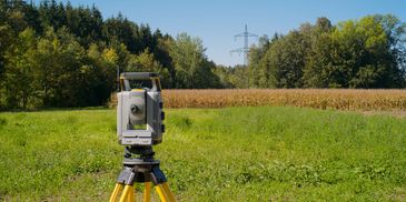
Topographic Mapping & Surveying
Topographic Mapping & Surveying
Topographic Mapping & Surveying
A specialized land survey that creates a detailed, three-dimensional map of a property, showing both natural and man-made features, their locations, and sizes.

GIS Mapping
Topographic Mapping & Surveying
Topographic Mapping & Surveying
Geographic Information System (GIS) surveying is a method that combines data, software, and hardware to capture, analyze, and display spatial data. Horizon Surveying can help you gather the data you need to build your GIS.
FEMA Flood Elevation Certificates
FEMA Flood Elevation Certificates
FEMA Flood Elevation Certificates
A community's permit file must have an official record that shows new buildings and substantial improvements in all identified Special Flood Hazard Areas (SFHAs). This elevation information is needed to show compliance with the floodplain management ordinance. FEMA encourages communities to use the Elevation Certificate developed by FEMA
A community's permit file must have an official record that shows new buildings and substantial improvements in all identified Special Flood Hazard Areas (SFHAs). This elevation information is needed to show compliance with the floodplain management ordinance. FEMA encourages communities to use the Elevation Certificate developed by FEMA to fulfill this requirement since it also can be used by the property owner to obtain flood insurance